Part 1 || Part 2 || Part 3 || Part 4 || Part 5 || Part 6 || Part 7 || Part 8
My dual cross country trip has to be one of the highlights of my flight training…it was overwhelming, but SO MUCH FUN! I had scheduled the plane for the morning of August 11th, but then I had to cancel because it was too cloudy.
But then God cleared the sky for me 😉
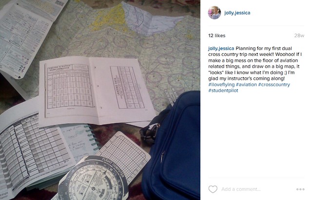
My Instagram post the night before my cross country, when I was trying to plan it. Oh it took soooo long that first time!
I actually had just texted Ted to see if I could go flying to practice maneuvers, because even if I couldn’t do my cross country, I wanted to get up in the sky! But he thought I was asking to go on the cross country, so he asked another guy who was scheduled to fly the plane that afternoon if he minded rescheduling…and we went flying!!! (Thank you, Jake!)

It took at least an hour…maybe two…for all of the pre-flight planning. Ted showed me how to plot the course, set checkpoints, calculate my airspeed and ground speed based on the winds, and then calculate how long it should take to get to each checkpoint. I also learned how to calculate fuel, to look up the airport radio frequencies, as well as the runway lengths and elevation of the airports I was landing at.
This is a picture of my first cross country flight…from Rochester (RCR), to Lafayette (LAF), to Muncie (MIE), and back to RCR 🙂 ‘Cross country’ sounds like you’re flying across the whole United States of America…but really it’s just 50 nautical miles between landing points 😉

I discovered the power of highlighters after my dual cross country…it helps a LOT! Because when you’re trying to fly a plane, and then you throw in a little turbulence…trying to find your thin pen line on a map full of lines is not easy! 😀
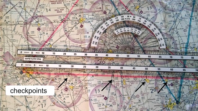
The next thing you do is pick out ‘checkpoints’ on the map. Either bigger towns, or highways, or sometimes railroads. You want to make sure it’s something you’ll be sure to recognize from the air! Then you make hash marks across your route line, and use your plotter to be able to tell how many miles are between checkpoints. After you calculate your airspeed and ground speed (and therefore how many miles per hour you are flying), you can calculate how many minutes it should take you to fly to each check point. This is called ‘pilotage’, which is basically keeping track of where you are without the use of GPS 😀
I was sososososo nervous about talking to ATC (air traffic control). Ted practiced with me at the hangar, him pretending to be the tower, and me replying back. That helped a lot. Then I went home and practiced it with myself, with my sisters laughing, “There you go again!!” 😀 However, they have no room to talk…with her EMT training, Cassia works on and talks to imaginary patients all of the time!
Leah and I share a room, so we’d be going to sleep, and I’d start saying, “Cessna 4378Quebec, Muncie Tower….Muncie Tower, 78Quebec, go ahead….78Quebec is 10 miles to the northwest, inbound, with information Oscar…78Quebec, expect runway two-one, report when you have the runway in sight….”
And Leah would tease, “I’m trying to go to sleep here!” 😀
For our first leg of the trip, from Rochester to Lafayette, Ted had me call Grissom Approach for flight following. Flight following is when the traffic controllers give you a number to punch into your transponder. They call this ‘squawking’, and there’s a neat article here about why it’s called ‘squawking’. The benefit of this is that someone else is keeping an eye on you, so if you get lost, or run into trouble, they know exactly where you are, (and also how high you are), and they can help you out. They are also like an extra pair of eyes when it comes to collision avoidance…they’ll tell you if there’s another plane in your area where you’re flying.
The transponder…what you punch your ‘squawk’ code into 🙂

I can still remember the first time I called Grissom. We had just gotten off of Rochester a few minutes before, and Ted practiced with me what to say, then he told me, “Okay, go ahead and give them a call!”
I blanked out..and I remember saying, “Oh brother!”
Ted told me, “Just go ahead and do it.”
So I did…and guess what! I didn’t die!
Me: “Grissom Approach, Cessna 4378Quebec”
ATC: “4378Quebec, Grissom Approach, go ahead”
Me: “4378Quebec is off of Rochester, en route to Lafayette, requesting flight following.”
ATC: “4378Quebec squawk 4231”
Me: “4378Quebec squawk 4231”
My first time was not very smooth…I’d say a few words, shut of the mic and look at Ted, and he’d tell me what to finish saying, then I’d key the mic again and finish the phrase.
Talking to ATC still unnerves me a bit, but it’s gotten way easier…and I love all of that ‘pilot speak’, lol! It’s fun to go to LiveATC.net and listen to ATC in real time while looking at an airport diagram.
Here’s another fun link…you can see aircraft flying all over the world. Their type, altitude, and even what code they’re squawking 🙂

For the first leg, Ted had me practice pilotage. Once in a while he’d ask, “What town is this?” and I’d look at the map, tell him what I thought it was, and he’d tell me if I was correct or not. I learned during this time about the tendency to descend when looking down at the map…or for my left hand to start to turn us left when I wasn’t paying attention!
It was when I started doing cross country flights that I discovered why pilots wear big watches. You need to keep track of the time for navigating and fuel, and trying to count minutes on a small watch while also watching six (or more) instruments, and looking at your map, and making sure you’re still flying the plane is rather difficult!
The plane has a clock, but I found it hard to keep track of minutes on it because it was small, and down by my knees, so it was hard to see. I used to not wear watches at all because I didn’t want to be bothered by them, and if I did wear one, it was a small one. Now I wear one almost every day. And I even like big watches now, haha! Whenever I see one of my older small watches I think, “Is this even a watch???”
When we flew over Ball State University, I mentioned to Ted that I took harp lessons there at one time, then later when he was asking me more pilotage questions, he said, “Notice I only ask you questions that I know the answers to! If you asked me about something over there, I’d say, “Now you play the harp, don’t you?!”
I told him that that reminded me of when I heard someone say once that God never asks questions because He needs information…Ted said that was a good way of putting it…then he said, “So for right now, just pretend that I’m like God!” LOL! We both laughed hard at that one 😀
I asked him how he got started flying, and he told me about his solo…he and his instructor had a skydiving business, so for Ted’s first solo, his instructor jumped out of the plane! Talk about a memorable solo!!!
Over the course of the flight, I talked to ATC a few different times…usually hearing them say “78Quebec…jibbery-jabbery-something-and-something-and-something…” and I’d look over at Ted like, “Quick! Translate for me!” and he’d tell me what to say back to them.
At one point, Ted told me I was doing a good job, then he said, “You sound professional!”
I replied, “Now I just need to bring you along on all of my flights so you can tell me what to say!”
But he told me not to count on that…bother! 😀
Another time they did their “78Quebec jibbery-jabbery…” and Ted told me to tell them “78Quebec, roger”. I repeated that, then I looked at Ted and asked him, “What did they just say? What did I just ‘roger’?” Haha!
I saw an airplane fly underneath me…and in Lafayette, I followed a plane while I was in the pattern. That was very cool!
At towered airports you’re required to ‘read back’ or repeat whatever the tower tells you to do. Even though it was intimidating to read back the taxi instructions to the tower because you have to remember what all they said, it was also cool to be doing it after having watched videos on it.
Airport Diagram of Lafayette (KLAF)
The dark black lines are the two runways. Runway 5/23 and 10/28.
The gray lines with C, C2, B, B5, etc. are the taxiways, so if you land on runway 28, and wanted to taxi to the terminal, tower might tell you to turn off of the runway onto “Charlie 1, right on Charlie, left on Bravo” or something of the like (see the pink line!).

The upper left hand corner has your important frequencies. ATIS is the frequency you tune into to listen to an automated recording tell you what the weather is in that area, tower is to talk to the tower of course ;), and GND CON is ground control…the people you talk to after you’ve landed and they need to move you around the airport!
Each hour they put out a new ATIS recording, and each hour has a letter assigned to it. So at the end of the recording they will tell you, “This is Information Alpha (or Bravo, or Charlie, etc…remember the post on the alphabet?)”.
“4378Quebec is ten miles to the northeast, inbound, with Information Charlie.”
Does that not sound cool? Yes it does 😀
I remember that Lafayette seemed very overwhelming because there were a few other airplanes in the pattern, and trying to remember to ‘turn right base for runway two-three’ (what was ‘right base’ again?!), and repeat everything he said to me was an experience! But that’s why you’re instructor is there, to help you how to learn to do it, one step at a time!
On the second leg, from Lafayette to Muncie, we used VOR for navigation. VOR is a radio frequency that you can tune into with your navigation radios. The radio frequency comes from a station on the ground that has 360 radio beacons…one for every degree heading on the compass:
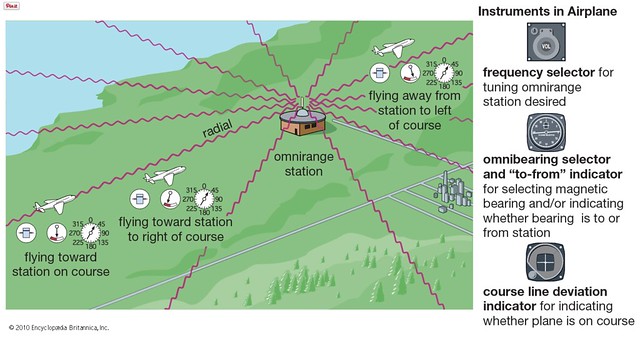 image via Encyclopedia Britannica for kids
Then there’s an instrument that has a needle that swings toward the signal, and you can tell which ‘radial’ or radio beacon you are on by turning that knob that says OBS until the needle is centered (the knob is turning the ring with the numbers on it at the same time). Below is a picture of the VOR indicator, and apparently this airplane is on the 360 radial (north):

image via Pilot’s Handbook of Aeronautical Knowledge
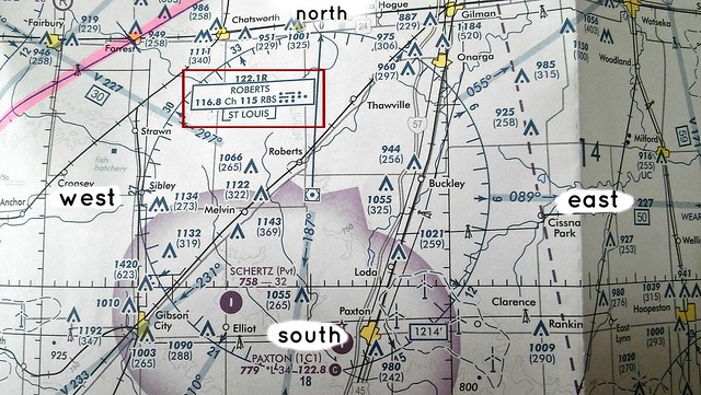
Here’s what the VOR stations look like on a map. You can see each of the little hash marks on the circle…those are the ‘radials’ 🙂 This is the ‘Roberts’ VOR station. 116.8 (in the red box) is what you would dial into your radio to tune into that station.
One way you can use VOR, is to fly directly to the station…like this one is in the middle of an airfield. So if I tuned into the Bloomington VOR, I could follow that needle all the way to the airport.
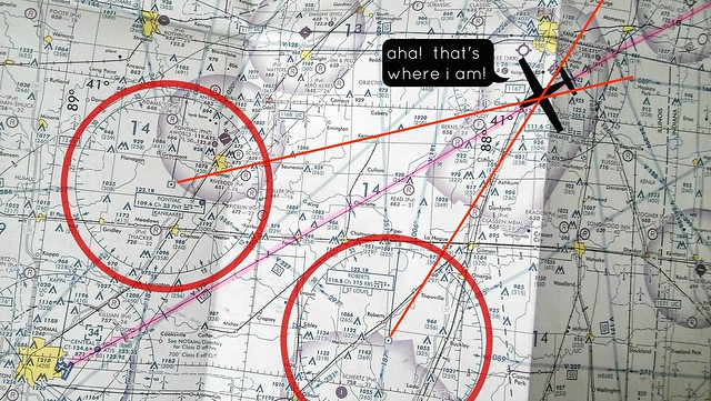
Another way you can use VORs is if you get lost. (Like I have a couple of times…but *ahem* I’ll tell you about those later 😀 ). Suppose I was on my way to BMI (Bloomington) and I got lost…I could find out exactly where I was on the map by tuning into two stations that are around me, lining up the dial to see which radial the needle centered on, and seeing where the two radials cross:
Now that I have thoroughly bored you with VORs…I’ll keep moving with the rest of my story, lol!
Muncie was much quieter, but still a towered airport so I could get practice talking to the tower and get the required towered airport landings in 🙂
The last leg was from Muncie to Rochester, and we used the easiest navigation…GPS 😀
At one point, I remember that there were fluffy white clouds just above us, and I realized, “I’m closer to those clouds than I am to the ground!” It was beautiful!
Once we got back to Rochester, we had winds gusting at 17 knots, which was more than I’m used to flying in. I remember before I soloed we had a gusty day, and I was watching Ted handle the yoke in response to what the wind was throwing at us, and wondering how on earth I would ever be able to do that. Then after my cross country when I was landing back at Rochester…I WAS DOING IT! It was so cool to begin to ‘feel’ the wind and the plane.
Ted had an airport meeting to go to, so I fueled up the plane by myself, and I wrote in my notebook, “…and I parked the plane without banging it–yay!” 😀
All in all, it was a lovely day! I felt like I was on information overload, but not so much so that it wasn’t fun. Learning how to juggle maps, while watching your altitude, and your heading, and timing your checkpoints, plus switching back and forth between radios, talking to ATC, and then getting your bearings around an airport you’ve never seen before, was overwhelmingly fun! I liked being stretched like that. 🙂
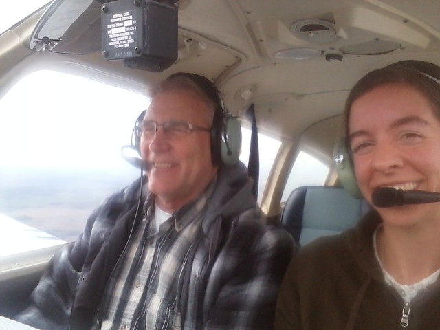
Ted and I…only this was another flight…because I was much too focused on my cross country to take any pictures that day, lol! Ted’s a fun instructor 🙂 I’ll ask him, “Can you take the plane while I take pictures?” and he laughs at me and lets me take a bunch!
Throughout my flight training, I had to keep reminding myself that I was only supposed to be focusing on the step that was right in front of me…and not to try to take in the big picture all at once. If I started thinking about what all I was supposed to be able to do in order to get my license, it was too overwhelming, and then it was likely I’d begin to get discouraged. I SO love flying…so I chose not to think about the big picture too much, because I didn’t want discouragement to steal any of the fun of flying right now! 🙂
I remember in ground school when Jim was talking about VORs, and ATC, and radials, and pilotage, and suction gauges, and airspeed indicators….I was thinking, “How will I EVER be able to remember how to work all of that???”. Then I’d remind myself that I just needed to focus on the next step, and my instructor would show me when to take the next step and how. It’s amazing what you can learn to do…just one little step at a time! You end up flying airplanes…all by yourself 😀

Subscribe to get our blog posts in your inbox!


Hi Jessica,
Looks like I have a lot of catching up to do reading all of these wonderfully informative blog posts! I didn’t know your first x-c was to LAF! Did you know I did most of my flight training there and I flight instructed there for 4 years!!! How fun. You brought back lots of memories!
Really?!! I didn’t know that you taught and did your flight training there! 😀 How neat is that??!!!!
You might have already read the first post in my story…but if not…you’re in there 😀
♥hugs!
-Jessica
I have now! It warms my heart to know the small role I played in your big journey! Congratulations! I’m going to come visit someday and you can fly me over to Purdue (LAF). I’ll pay for gas and buy you lunch! I bet you could reteach me a thing or two! Those 3000 hours of dual given in my logbook were over 20 years ago now! ?
God definitely put you into my life and used you to encourage me, for sure! ♥
That would be AWESOME to take you flying 😀 When are you coming? Lol!
Hehe! I’m sure YOU could teach me a thing or two, for sure 😉
That’d be so much fun!
♥ Jessica
Glad you had fun!!!!
What the jolly.jessica account? 😀
Hehe! It’s my Instagram account 😀 -Jessica
I found this post so inspiring!! Flying a plane is probably one of the most scariest things I could choose to do, at least in my opinion.
But the part about worrying only about what’s “right in front of me” really spoke to me. I have a chronic illness that often requires some long-term treatment, and then even longer recovery periods, and I frequently get ahead of myself, worrying about “how will I ever get that much better?” or “how will I ever get everything around me done?”.
Thank you for setting that example.
Also, I really enjoy reading your blog, even though we have very different lives!
All my best,
Toni
Thank you, Toni! I’m so, so glad my journey could be an encouragement to you! I was reading your blog, and you are one brave lady as well!
{hugs!}
♥ Jessica